Index of USGS 7.5' Connecticut DEMs

image map of Connecticut

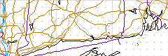
Click on a location within the state to pick your 7.5' USGS DEM files. Each 7.5' map quad is 10x10 pixels on this imagemap or select them from a list.

sherwood point norwalk south stamford clinton oe s guilford oe s branford oe s woodmont milford bridgeport westport norwalk north mystic new london niantic old lyme essex clinton guilford branford new haven ansonia long hill botsford bethel old mystic uncasville palmertown hamburg deep river haddam durham wallingford mount carmel naugatuck southbury newtown danbury voluntown jewett city norwich fitchville colchester moodus middle haddam middletown meriden southington waterbury woodbury roxbury new milford oneco plainfield scotland willimantic columbia marlborough glastonbury hartford south new britain bristol thomaston litchfield new preston kent east killingly danielson hampton spring hill coventry rockville manchester hartford north avon collinsville torrington west torrington cornwall ellsworth thompson putnam eastford westford stafford springs ellington broad brook windsor locks tariffville new hartford winsted norfolk south canaan sharon

Go to another state:

ak, al, ar, az, ca, (ca:sfba), co, ct, dc, de, fl, ga, hi, ia, id, il, in, ks, ky, la, ma, md, me, mi, mo, ms, mt, nc, nd, ne, nh, nj, nm, nv, ny, oh, ok, or, pa, ri, sc, sd, tn, tx, ut, va, vt, wa, wi, wv, wy.


Page first created Wednesday, May 31, 2000
Page last modified Monday, September 11, 2000 11:20 PM