
|
| Milford Sweat, Idaho |
This is an index to my information and resources for hot spring adventures. I have maping tools, some links to other pages, and even a few descriptions from personal experience.
The individual hot spring maps are 0.1 degree squares centered about the spring rendered as 400x400 pixels. These maps show all details available including dirt roads and are to be used for "final approach."
TIGER maps have an advantage over MapBlast in that they can (and in the case of these maps, usually do) have more than one spring plotted on them.
The individual hot spring maps are 1:32000 scale (at 72 dpi) squares centered about the spring rendered at 400x400 pixels. These maps show street level details available from MapBlast! for use in "final approach" to the spring.
 |
 |
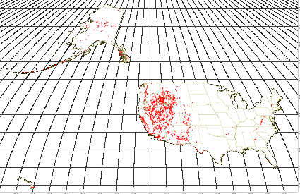
| Map of all hot springs & craters in the USA. Click on the image to get a live map from the TIGER server. |
Return to Mapping page or go up to DavidWoolsey.com.
Page first created Friday, June 30, 2000
Page last modified Saturday, August 6, 2005 11:13 PM